這個網頁對於 Keyline 的介紹十分詳細,不過,我想還是要找一個真正的地形圖模型來,才有機會把 keyline, keypoint, main ridge, primary valleys, primary ridges 搞清楚。
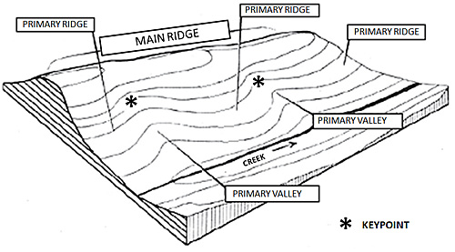
簡單的說,要找 keyline,就要先找到 keypoint。Keypoint 在那裡?在實踐者口中的描述是「the highest point on the landscape where one can cost effectively hold water(一個在地形上可以有效守住水的最高點)」,它位於 primary valley,凸面與凹面交界附近,有沈澱現象的地方。經過 keypoint 的等高線就是 keyline。
The Keypoint
(The Most Important Point on Your Land)
The Keypoint is vital to the proper implementation of Keyline. In any valley, no matter how small, there is a path down the center of that valley that water will collect and run downhill. Along this central path, the slope of the land will change from convex (where the water is shed or runs) to concave (where the water collects or slows down). You can easily see this point in the illustration. It is important to note that this transition or inflection point from convex to concave is NOT the true Keypoint according to P.A. Yeomans. Many practitioners will use this inflection point as the Keypoint, and I don’t think there is a huge difference, but it is not the same. According to Yeomans, the Keypoint is really the point just a little farther downhill, still along this central path of the valley, where the force of water movement changes from erosive to deposition(水流的移動從沖刷變為沈澱). Typically, this means the Keypoint is just a bit downhill from the inflection point. On steeper slopes, the Keypoint is close to the inflection point. On more gentle slopes, the Keypoint is farther away from the inflection point.

An introduction to the basic principles of the land and water design system known as Keyline.
Source: An Introduction to Keyline | Temperate Climate Permaculture & Keyline Plowing: What is it? Does it work?